Route Overview
Region
Michigan
Wisconsin
Miles
Days Out
Physical Difficulty
Season
Elevation Gain
Tire Size
Technical Difficulty
Route Map
Route Details
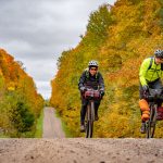
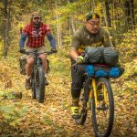
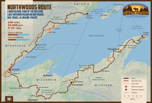
The 600-mile-long Northwoods Route circumnavigates the western half of Lake Superior, following gravel roads, relatively smooth two-tracks, rail trails, and short sections of pavement through thick forests and along countless lakes. This loop was created for riders on both mountain or gravel bikes, with relatively frequent resupply options along the way. Singletrack alternates and trail networks offer options for riders looking for more loaded or unloaded technical riding opportunities.
The loop uses the passenger ferries that travel to Isle Royale National Park to cross Lake Superior. This connection requires some planning since the ferries do not run daily, and the lake crossing will require an overnight stay on Isle Royale (see the FAQ below for more information). We also encourage riders to spend an extra day or more hiking on Isle Royale (bikes cannot be ridden on the island).
- What kind of bike should I ride? We recommend a mountain or gravel bike with tires at least 1.75” wide.
- What’s the ideal time of year to ride the route? Generally early May to early October, but it depends on the year. See the route guide for more details.
- How long will the route take to ride? Generally 9 to 12 days of riding, plus a day or two for the ferry and time on Isle Royale, but it depends on the rider.
- Do I need any special permits? No permits are needed for riding on this route.
- Are there any specific safety considerations on this route? Biting insects (black flies, mosquitoes and flies) can be common along the route. We strongly recommend carrying insect repellant and a shelter to keep the swarms at bay. This route also traverses black bear country. See the route guide for more details.
- What is the longest distance between water sources? 40 miles, although water is abundant on most of the route. See the route guide for more details.
- What is the longest distance between resupplies? 75 miles. See the route guide for more details.
-
- Is it easy to find places to camp? Yes and no. The route crosses a mix of public and private lands, with private campgrounds along the way. See the route guide for more details.
- Can I ride the route in either direction? Yes.
- How do I follow the route? These routes are not marked on the ground in any way. You will need to load the route data onto a GPS unit.
-
- How do the Isle Royale ferries work? There are four ferries that travel to Isle Royale, two to/from Grand Portage, MN to Windigo on the southern tip of Isle Royale, one to/from Rock Harbor to Houghton, MI, and one to/from Rock Harbor on the northern tip of Isle Royale to Copper Harbor, MI. It will require two ferries to cross Lake Superior, an overnight stay on Isle Royale (likely at the Rock Harbor campground), and a bit of planning based on ferry schedule since they do not operate on daily schedules. All carry bikes for an additional fee, and the total cost for tickets/fees is around $200 per person for the crossing (plus a small daily use fee and camping fee at Isle Royale National Park). We strongly recommend calling the ferry services in advance to make reservations and ensure that there is space for your bike.
- Voyageur II ferry: Runs from Grand Portage, MN to Windigo and then along the coastline of Isle Royale to Rock Harbor. This ferry is required to connect from one end of Isle Royale to the other. Operates annually from mid-May to the end of September. Riders can connect to Michigan on either the Queen IV ferry to Copper Harbor or the Ranger III ferry to Houghton.
- Sea Hunter II ferry: Runs from Grand Portage, MN to Windigo. Operates annually from early June to early September. Riders using this ferry would need to also connect with the Voyageur II ferry to reach Rock Harbor and then the Queen IV or Ranger III ferry to reach Michigan.
- Queen IV ferry: Runs from Copper Harbor, MI to Rock Harbor on most days of the week during peak season. Operates annually from mid-May to the end of September. Riders using this ferry will need to then arrange a trip on the Voyageur II ferry to reach Grand Portage.
- Ranger III ferry: Runs from Houghton, MI to Rock Harbor two days per week. Operates annually from late May to mid-September. Riders can connect to the Ranger II to connect to Grand Portage.
- How do the Isle Royale ferries work? There are four ferries that travel to Isle Royale, two to/from Grand Portage, MN to Windigo on the southern tip of Isle Royale, one to/from Rock Harbor to Houghton, MI, and one to/from Rock Harbor on the northern tip of Isle Royale to Copper Harbor, MI. It will require two ferries to cross Lake Superior, an overnight stay on Isle Royale (likely at the Rock Harbor campground), and a bit of planning based on ferry schedule since they do not operate on daily schedules. All carry bikes for an additional fee, and the total cost for tickets/fees is around $200 per person for the crossing (plus a small daily use fee and camping fee at Isle Royale National Park). We strongly recommend calling the ferry services in advance to make reservations and ensure that there is space for your bike.
- Are bikes allowed in Isle Royale National Park? They are not, except for at the dock areas and in the two main campgrounds. Bikes are not permitted on any trails, and the Park Service requests that riders walk their bikes between the dock and campground.
If you encounter any inaccuracies or changes please let us know at [email protected]
Updates affecting the Northwoods Route (last updated 20 June 2023)
- Isle Royale National Park: The National Park Service (NPS) is now requiring that riders leave their bicycles locked up at the bike racks adjacent to the ferry docks. Bikes are NO LONGER ALLOWED in the Rock Harbor and Washington Creek Campgrounds. Also, these campgrounds now have stay limits of 1 night and 3 nights, respectively. For more information on bikes in Isle Royale National Park, please visit this page from the NPS.
- Solon Springs, Wisconsin: A short detour was recommended by riders in 2022 to bypass incredibly soft gravel on the rail trail immediately north of Solon Springs. Here is the recommended detour in Ride With GPS.
- Shimano for their support.
- Otso Cycles for their support.
- Kurt Refsnider for his route development.
- Eric Braun, Jon Dicus, Dan Corning, Max Elfelt, Nick Karwoski, Joe Riemensneider and Ben Weaver for their contributions.
- This route traverses the traditional lands of the Anishinabewaki people.
Segments
- Duluth to Grand Portage
- 217 miles
- 7,600’ elevation gain
- 70% natural surfaces, 30% paved
- 3-5+ days out
- 4.5/10 physical difficulty
- 3.5/10 technical difficulty
The North Shore of Lake Superior is an especially beautiful landscape – cobbly beaches, long cliff lines, narrow canyons, and the uplands that climb away from the shoreline. This segment begins in the city of Duluth on a paved recreation path before climbing inland and out of town on a series of quiet paved and gravel roads. Duluth features numerous public transportation options and any and all services one could need before embarking on a trip. Farther up the North Shore from Duluth, the route drops back down to the coast and follows a paved recreation path past numerous state parks. At Silver Bay, riders will head inland once again, climbing into the highlands on primarily gravel roads, some rougher than others, and past countless small lakes. North of Finland, the route enters Superior National Forest, and dispersed camping opportunities become plentiful between there and the final miles of Segment 1. Riders will return to Lake Superior at the bustling town of Grand Marais before heading inland once again toward Devils Track Lake and the Canadian border on some of the roughest roads of the segment. The final miles of the segment cross the Grand Portage Reservation of the Grand Portage Band of Lake Superior Ojibwe, and the segment ends at Grand Portage (Gichi-Onigaming). Here, riders can take either the Voyageur II or Sea Hunter II ferry to Isle Royale National Park.
- Copper Harbor to the Wisconsin Border at Ironwood
- 226 miles
- 8,000’ elevation gain
- 75% natural surfaces, 25% paved
- 3-5+ days out
- 4.5/10 physical difficulty
- 4.5/10 technical difficulty
The Michigan segment traverses ancient but still-rugged mountain belts and is the most demanding (and arguably scenic) segment of the Northwoods Route. For riders coming across from Isle Royale National Park on the Isle Royale Queen IV ferry, Copper Harbor is the starting point for Segment 2 (riders coming across on the Ranger III ferry will land in Houghton). Copper Harbor is nestled on the northernmost end of Michigan’s Keweenaw Peninsula, and from this small touristy community, the route winds its way south on logging roads, a few short but steep sections of 4×4 tracks, and gravel roads. Closer to Calumet, the riding becomes easier on the rail trail toward the small city of Houghton. Continuing south, pleasant gravel roads, more rail trail, and short sections of pavement lead toward the mountains around Greenland. The rockiest, most rugged section of the entire route sits between Greenland and Rockland, but beyond Rockland, the forest roads become smoother once again. Reaching the Lake Superior shoreline again, the route enters the beautiful Porcupine Mountains Wilderness State Park. Nearly the entirety of the riding from there to the end of the segment near Ironwood is paved. The only alternate along this segment is the Twin Lakes Alternate, a short paved and gravel option that takes riders out to a beach and campground on the coast.
- Wisconsin Border at Ironwood to Duluth
- 189 miles
- 4,000’ elevation gain
- 80% natural surfaces, 20% paved
- 3-4+ days out
- 4.5/10 physical difficulty
- 3/10 technical difficulty
Wisconsin is the shortest, least rugged, and but most remote of the Northwoods Route segments. The vast majority of the riding is on gravel roads (aside from between Solon Springs and Duluth), services are relatively far apart, and natural water sources are a bit less frequent. Leaving Ironwood, Michigan, the route crosses into Wisconsin and enters the mostly undeveloped Ashland County Forest lands. The roads get rougher and narrower before gradually becoming better again toward the Chequamegon National Forest boundary. Once in the national forest, the topography becomes much more challenging as the roads climb over and squirm around ridges and hills of glacial deposits. The small town of Cable, a mountain bike destination due to the local CAMBA trail system, is the first community along this segment. North of Cable, the riding becomes faster and smoother all the way to Solon Springs, although short sections can be quite sandy when dry. North of Solon Springs, the route zigzags toward Superior and Duluth on mostly paved backroads. The CAMBA Alternate offers a challenging singletrack option east of Cable, and the Duluth Traverse Alternate turns off the main route south of Superior to reach the southern terminus of the Duluth Traverse singletrack.


